You don’t need to bother owning surveying instruments if you are not having projects regularly or you have a project in East Africa while you are operating from abroad. SESC has a solution for you. We hire surveying equipment at a very reasonable cost. Since we are expert on handling these instruments we always make sure that the instrument that is hired is well calibrated before handing over to our customers. Moreover for projects that take long period of time our cost goes down in order to ensure that we reach a win win situation between SESC and our customer.
The instruments that we hire are as follows, Automatic Levels, Total Station and GNSS receiver. In the near future we are aiming to have UAV (Drone) for the same purpose.
| Automatic level Hire South Automatic/ Digital level from SESC to receive precise readings. All our levels are high quality and we always calibrate before issuing to the client and we provide calibration certificate. With instrument we also provide 5m levelling staff and wooden or aluminum tripod. |
|
 |
Total Station Hire a South Total Station from SESC to receive precise readings. Our instruments are fully calibrated at our modern workshop and we provide calibration certificate. At SESC we hire Standard Total Stations for normal survey work and setting out and Reflector less total Stations for normal survey work and the prism less measurements for those areas that cannot be reached easily such as cliffs, steelworks and the like. |
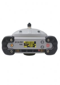 |
GNSS receivers Hire a South RTK GNSS receiver S86 and utilize the latest GNSS technology to conduct your survey and stakeout job. Our South S86 is available in Base and Rover system and it can be provided more than one rover as requested. |
| Skywalker: The description of our Skywalker is as follows: It is a Hexacopter with six rotary wings, carbon fiber polymer composites made, dimension 120cmx40cm, standard payload 1.5kg, maximum take-off weight 11kg, climb speed 4m/s, cruise speed 8-10m/s, double flight control system, maximum flight altitude 3500m (AMSL), effective flight radius 5km, image resolution 2-10cm, automatic or manual flight mode optional, duration per flight 50-60 minutes, with flight control software Zero-tech GCS. |
|
| Sky cruiser: The Description of our Cruiser is as follows: Drone, fixed wing, EPO made, aircraft length 0.8m, wingspan 1.2m, maximum take-off weight 2.4kg, ejector rack launch, maximum flight altitude 3000m (AMSL), cruise speed 72km/h, single flight mission 10 sq.km, duration 80 minutes, with flight control software GCS. |
|
| SkyPhoto Our post processing software is called SkyPhoto. The description of our skyphoto is as follows: Aerial photogrammetry post processing software, with orthomosaic, aerial triangulation, DEM editing modules, DOM/DSM/DEM and point cloud outputs, 3D modeling and browse, DLG (Digital Line Graphics) production based on stereo image pair.It is in the future plan of SESC to retain each type of drone for hiring. |